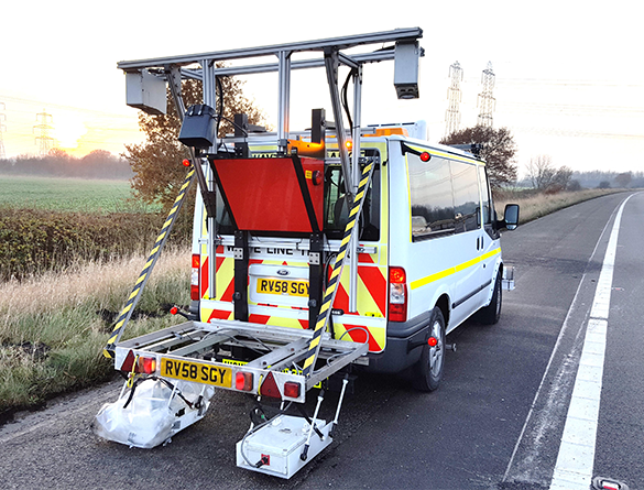
Visual Condition Surveys (VCS) are used to record the current condition of the surface of the pavement. VCS can be undertaken either as a walked survey or at traffic speed using specialist imaging equipment.
Traffic speed VCS has several advantages over walked inspection, such as:
• Removes the inherent health and safety risk of putting operatives in the carriageway
• Remove the need for traffic management, reducing cost and removing delays for road users
• Provides an auditable process and improved quality output
Traffic speed VCS is conducted from TRL’s specialist survey platform amongst live traffic without the need for traffic management. The vehicle includes an ultra-wide aspect forward facing imaging system, downward facing pavement line scanning cameras and the spatial referencing system, as detailed in Table 1. The vehicle itself is compliant with Traffic Signs Manual Chapter 8.
The proposed system provides additional benefits over a standard collection system by:
- providing ultra-wide aspect imagery of the carriageway
- including downward facing imagery, enabling an enhanced visual condition assessment compared to forward facing imagery especially in terms of crack identification
- including an integrated spatial referencing system capable of delivering ±50 cm accuracy
The visual condition assessment of the images will be carried out by trained personnel experienced in delivering video based VCS surveys. The assessment will be conducted within TRL’s “ChartCrack” software which has been designed to meet the requirements of Design Manual for Roads and Bridges CS 229 Data for pavement assessment. The results can be provided as strip maps of defects, tables of defects and shapefile.
Given the inherent risk of placing operatives on or adjacent to the carriageway, we aim to avoid walked VCS surveys where possible. Where walked VCS are required, they will be undertaken by trained and experienced engineers with results annotated onto site schematics.
Table 1: Digital Image Collection Specification for VCS
|
System |
Parameter |
Detail |
|
Forward Facing Images |
Resolution |
3072 x 1372 pixel |
|
Format |
JPG |
|
|
Image Interval |
5 m |
|
|
Lighting |
Ambient with dynamic exposure normalisation of each frame |
|
|
Downward Facing Images |
Image resolution |
4096 x 1 pixel (each pixel represents ~1mm of pavement) |
|
Image interval |
2mm |
|
|
Image width on pavement |
3950mm |
|
|
Format |
JPG |
|
|
Lighting |
Laser illuminated |
|
|
Spatial Referencing |
DMI |
Twin wheel encoders |
|
DGPS |
Trimble Omnistar D-GPS system |
|
|
IMU |
OXTS Inertial+ |
For a quotation or further information about a VCS of your scheme, please contact the Service desk directly by email.

